Approximate Location Map
Large Map »
This site is entirely user-supported. See how you can help.
Latitude: 54.2874 / 54°17'14"N
Longitude: -0.8746 / 0°52'28"W
OS Eastings: 473357.682381
OS Northings: 488559.592077
OS Grid: SE733885
Mapcode National: GBR QLBV.FV
Mapcode Global: WHF9N.JHRK
Entry Name: High Cross wayside cross on Kirkgate Lane, north of Appleton-le-Moors
Scheduled Date: 19 October 1995
Source: Historic England
Source ID: 1012887
English Heritage Legacy ID: 25636
County: North Yorkshire
Civil Parish: Appleton-le-Moors
Traditional County: Yorkshire
Lieutenancy Area (Ceremonial County): North Yorkshire
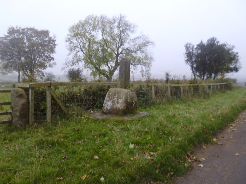
The monument includes a wayside standing cross known as High Cross on the lane
from Lastingham to Appleton-le-Moors. It consists of a massive cross base of
local sandstone and a portion of a shaft of the same stone set in the base.
The cross is set on a modern plinth of sandstone and cobbles. The cross stands
in its original position on the west side of the road, opposite the entrance
to a drove road called Wensdale Lane.
The plinth is polygonal and is 2m wide on its north-south axis. The base
is 0.73m high and at the bottom is 0.9m across and 0.71m deep. This tapers to
0.64m wide and 0.57m deep at the top. The cross shaft is in a socket and
secured with lead. The shaft shows 0.97m above the base and is rectangular in
section 0.36m by 0.21m where it meets the base. The shaft is chamfered on the
corners and worn.
The massive base and slender chamfered shaft indicate a cross which may
originally have stood 3m high. The proportions suggest an important way marker
on the road to Lastingham and a focus of worship in the medieval period.
The surface of the road is excluded from the scheduling but the ground beneath
it is included.
MAP EXTRACT
The site of the monument is shown on the attached map extract.
It includes a 2 metre boundary around the archaeological features,
considered to be essential for the monument's support and preservation.
Source: Historic England
Wayside crosses are one of several types of Christian cross erected during the
medieval period, mostly from the 9th to 15th centuries AD. In addition to
serving the function of reiterating and reinforcing the Christian faith
amongst those who passed the cross and of reassuring the traveller, wayside
crosses often fulfilled a role as waymarkers, especially in difficult and
otherwise unmarked terrain. The crosses might be on regularly used routes
linking ordinary settlements or on routes having a more specifically religious
function, including those providing access to religious sites for parishioners
and funeral processions, or marking long-distance routes frequented on
pilgrimages.
Over 350 wayside crosses are known nationally, concentrated in south west
England throughout Cornwall and on Dartmoor where they form the commonest type
of stone cross. A small group also occurs on the North York Moors. Relatively
few examples have been recorded elsewhere and these are generally confined to
remote moorland locations.
Outside Cornwall almost all wayside crosses take the form of a `Latin' cross,
in which the cross-head itself is shaped within the projecting arms of an
unenclosed cross. In Cornwall wayside crosses vary considerably in form and
decoration. The commonest type includes a round, or `wheel', head on the faces
of which various forms of cross or related designs were carved in relief or
incised, the spaces between the cross arms possibly pierced. The design was
sometimes supplemented with a relief figure of Christ and the shaft might bear
decorative panels and motifs. Less common forms in Cornwall include the
`Latin' cross and, much rarer, the simple slab with a low relief cross on both
faces. Rare examples of wheel-head and slab-form crosses also occur within the
North York Moors group. Most wayside crosses have either a simple socketed
base or show no evidence for a separate base at all.
Wayside crosses contribute significantly to our understanding of medieval
religious customs and sculptural traditions and to our knowledge of medieval
routeways and settlement patterns. All wayside crosses which survive as earth-
fast monuments, except those which are extremely damaged and removed from
their original locations, are considered worthy of protection.
The High Cross wayside cross survives well in spite of the loss of the head
and part of the shaft. Although it has been re-erected in modern times it
stands in its original position. It stands on Kirkgate Lane, the old route
which leads to the early medieval church at Lastingham. It forms part of a
relict medieval landscape in which the crofts of the village of Appleton
survive and the surrounding strip cultivated fields are defined by the later
enclosure boundaries.
Source: Historic England
Books and journals
Hayes, R H, Old Roads and Pannierways in North East Yorkshire, (1988), 56
Eyre, S R, 'Ryedale Historian' in Coxwoldshire, , Vol. 16, (1993), 13-20
Source: Historic England
Other nearby scheduled monuments