Approximate Location Map
Large Map »
This site is entirely user-supported. See how you can help.
Latitude: 56.5866 / 56°35'11"N
Longitude: -6.1732 / 6°10'23"W
OS Eastings: 143865
OS Northings: 751646
OS Grid: NM438516
Mapcode National: GBR CC49.P62
Mapcode Global: WGZD4.4QN0
Entry Name: Kilmore,standing stones 230m SE of
Scheduled Date: 7 January 1985
Source: Historic Environment Scotland
Source ID: SM4351
Schedule Class: Cultural
Category: Prehistoric ritual and funerary: standing stone
Location: Kilninian and Kilmore
County: Argyll and Bute
Electoral Ward: Oban South and the Isles
Traditional County: Argyllshire
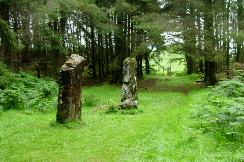
The monument consists of four monoliths, one of which has probably been moved to form a gatepost. The three in their original position point NNW/SSE. The monument is of national importance as part of the theme of prehistoric astronomy. The study of prehistoric astronomy demands statistical assessment of well defined groups of megalithic sites. In N Mull there are eight alignments of up to six stones, a remarkable concentration given the sparse distribution of such sites elsewhere in Scotland. The alignments show a marked preference for the N and S quadrants.
Source: Historic Environment Scotland
This group of sites is of national importance and preservation of its components for meticulous survey, skyline surveys and dating by archaeological means should have a high priority. These sites can illuminate the intellectual achievements of early prehistoric man in Britain in a way that non-megalithic as well as non-megaxylic sites cannot. The implications for studies of social organisation are also of high importance.
Source: Historic Environment Scotland
Bibliography
RCAHMS records the monument as NM45SW 7.
Source: Historic Environment Scotland
Other nearby scheduled monuments