Approximate Location Map
Large Map »
This site is entirely user-supported. See how you can help.
Latitude: 55.6639 / 55°39'50"N
Longitude: -3.4792 / 3°28'45"W
OS Eastings: 307046
OS Northings: 642149
OS Grid: NT070421
Mapcode National: GBR 424Y.KG
Mapcode Global: WH5SP.JWGV
Entry Name: High House of Edmonston,tower house
Scheduled Date: 27 April 1992
Source: Historic Environment Scotland
Source ID: SM5277
Schedule Class: Cultural
Category: Secular: castle
Location: Biggar
County: South Lanarkshire
Electoral Ward: Clydesdale East
Traditional County: Lanarkshire
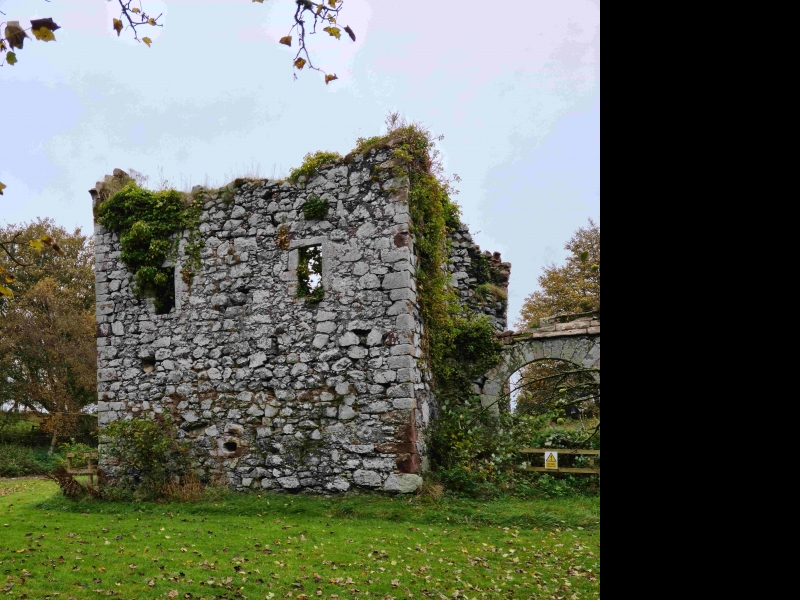
The monument consists of the remains of a fortified residence probably built during the middle of the fifteenth century.
The tower is situated in a hilly area on the W side of the Candy Burn midway between Biggar and Dolphinton. The three storeyed house measures 7.9m NE-SW by 7.3m over walls 1m thick. The walls survive to wall head (8.2m Max ht) apart from the NE and most of the SW walls which were destroyed in 1872. The tower had crowstepped gables (a small section survives in the SW wall). It has a circular external
tower projecting from the N angle which housed the staircase. The entrance is in the NW wall next to the stair turret. The ground floor contains a vaulted cellar with a shot hole in the SE wall. There is a slit window in the NE wall. The hall occupied the whole of the first floor. It is lit by one window in the NE and two in the SE wall.
There is a small cupboard in the SW wall. The floor above contained one room with two windows above those in the hall and a window and fireplace with moulded corbels in the SE wall. There is a small window in the SW wall. The tower has a wall containing an entrance gateway with a semi-circular headed archway. This wall, originally part of a courtyard, projects some 6.1m from the NE wall. A second house stood in the courtyard but this was demolished in 1815. The
tower itself is built of random rubble with some dressed stones (used liberally in the gateway). The courtyard was cobbled and there is a slight ditch and bank to the NE running NW-SE.
The area to be scheduled is irregular and measures a maximum of 40m N-S by 35m E-W, excluding the surrounding fence, as shown in red on the accompanying map.
Source: Historic Environment Scotland
The monument is of national importance because it is a fine example of a simple fifteenth century tower which also promises through excavation to contribute further to our knowledge of medieval building construction, domestic occupation and material culture.
Source: Historic Environment Scotland
Bibliography
RCAHMS records the site as NT04SE 6.
Source: Historic Environment Scotland
Other nearby scheduled monuments