Approximate Location Map
Large Map »
This site is entirely user-supported. See how you can help.
Latitude: 55.3257 / 55°19'32"N
Longitude: -3.7309 / 3°43'51"W
OS Eastings: 290278
OS Northings: 604874
OS Grid: NS902048
Mapcode National: GBR 26DV.2Q
Mapcode Global: WH5V9.NDLM
Entry Name: Durisdeer, Roman fortlet between Dash Cleuch and Kirk Burn
Scheduled Date: 1 April 1924
Last Amended: 16 January 1996
Source: Historic Environment Scotland
Source ID: SM670
Schedule Class: Cultural
Category: Roman: fortlet
Location: Durisdeer
County: Dumfries and Galloway
Electoral Ward: Mid and Upper Nithsdale
Traditional County: Dumfriesshire
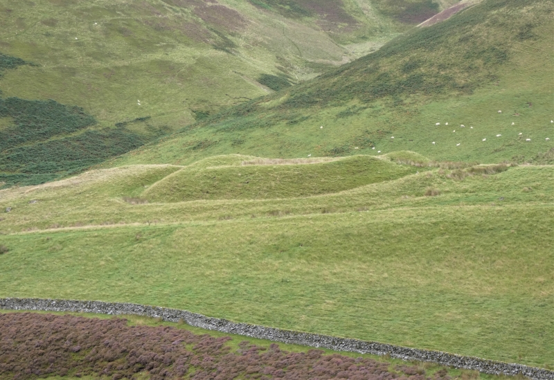
The monument comprises the well-preserved remains of a Roman fortlet, set beside what may be a Roman road.
The fortlet has been partly excavated, in 1938, and proved to have two episodes of occupation, both during the Antonine period. The fortlet was formed by cutting into a natural spur and measures 18m by 24m internally. It has a steep-faced inner rampart within a ditch, outside which is a slight outer bank. The entrance, on the NE, is some 3m wide and has a broad causeway over the ditch. 22m NE of the entrance is a slight depression which marks the titulus, or outer gateway defence.
The area to be scheduled is oval, some 90m NE-SW by 65m, to include the fortlet, its ditch and outer bank, and the titulus to the NE, as marked in red on the accompanying map.
Source: Historic Environment Scotland
The monument is of national importance as a well-preserved Roman fortlet in a typical location beside a Roman road. It has proven archaeological potential to provide information about the date of use of such fortlets and their detailed construction and re-development over the duration of the Roman presence.
Source: Historic Environment Scotland
Bibliography
No Bibliography entries for this designation
Source: Historic Environment Scotland
Other nearby scheduled monuments