Approximate Location Map
Large Map »
This site is entirely user-supported. See how you can help.
Latitude: 55.9497 / 55°56'59"N
Longitude: -4.8096 / 4°48'34"W
OS Eastings: 224660
OS Northings: 676531
OS Grid: NS246765
Mapcode National: GBR 09.Y5H5
Mapcode Global: WH2M9.2QZ7
Entry Name: Larkfield Battery, anti-aircraft battery 175m ESE of 1 Hilltop Road
Scheduled Date: 25 March 2011
Source: Historic Environment Scotland
Source ID: SM12826
Schedule Class: Cultural
Category: 20th Century Military and Related: Battery
Location: Inverkip
County: Inverclyde
Electoral Ward: Inverclyde West
Traditional County: Renfrewshire
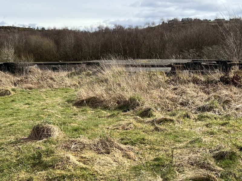
The monument comprises the remains of the Larkfield heavy anti-aircraft battery, dating to the Second World War. The battery consists of a command post, several gun emplacements and a number of associated buildings. The site is located on a plateau overlooking Greenock, Gourock and the Clyde Estuary at around 90m above sea level.
The battery now lies in an area of scrubland adjacent to the Coves Reservoirs. The site consists of a command post, four upstanding gun emplacements with two further gun emplacements surviving as scrub-covered mounds of rubble, two visible 'holdfasts', two ammunition magazines, two outbuildings and a single gun store for small arms.
The command post is a partially buried four-cell brick and concrete structure in the centre of the site. Attached to the exterior of the command posts are three connected open positions with concrete blast walls, which would have housed the targeting equipment for the battery in the form of a Predictor and a Height-finder. The roofed building of the command post measures around 15m NNW-SSE by around 12.5m transversely, with the external positions attaching to its SW corner and measuring around 14m NNW-SSE by 5m transversely.
The four surviving gun pits are all octagonal on plan and measure around 13m in diameter. They are constructed of reinforced concrete and comprise two walls each forming three sides of the octagonal shape, with the remaining two sides left open for access, one facing inwards towards the command post and the other facing outwards to the magazines. Against the exterior of each wall further earth has been piled up to increase the protection against blast damage. Attached to the interior side of each wall would have been three ammunition lockers, although several of these have now collapsed or been removed. Visible on the magazine entrance of the NW example, as a blast precaution, is an offset entrance constructed of brick. It is unclear whether the other examples also formerly held these. In the centre of two of the emplacements the 'holdfasts' are visible that provided the mounting for the guns. The N and the SE emplacements each have an additional outbuilding attached, in the form of a brick and concrete single cell structure attached to the exterior of the blast walls. Each of these has an entrance facing the command post and a small vent in the opposite wall. Both of the entrances have been partially blocked with later walling, probably to prevent interior access. These are likely to have been crew shelters or possibly generator rooms to supply the emplacements later in the war.
To the south of the command post are the remains of the two final emplacements. These were added to the battery in around 1943 and were of a square form rather than octagonal, to accommodate new equipment being used by this stage of the conflict. They were demolished relatively recently and now survive as two large scrub-covered mounds of rubble.
The magazines survive towards the N and W edges of the site. They lie outside the arc of the original four gun emplacements, with each example located halfway between the two emplacements it served. Each magazine is a rectangular structure around 13m in length by around 5m wide. They are constructed of reinforced concrete with a single entrance and with partitions dividing the interior into five cells. Three concrete ramps lead to the entrance of each magazine, with one of these running straight between the emplacements towards the command post and the centre of the site, and the remaining two each curving up to the outer entrance of one the emplacements it served.
The final visible element of the site is the gun store, which lies to the NE of the site, outside the arc of the gun emplacements. The gun store is a rectangular building measuring around 8m SW-NE by around 7m transversely and constructed of reinforced concrete with four windows in its NW side. Attached to its NE side is a small extension added to the building at a later date to house a toilet.
The area to be scheduled is polygonal on plan, to include the remains described above and an area around within which evidence relating to the monument's construction, use and abandonment may survive, as shown in red on the accompanying map.
Source: Historic Environment Scotland
Cultural Significance
The monument's cultural significance can be expressed as follows:
Intrinsic characteristics
This well-preserved example of a heavy anti-aircraft (HAA) battery dates to the Second World War. It is an exceptionally well-preserved example of a monument that would have been a common and familiar sight in the 1940s. Given the excellent level of preservation of the site there is a high potential for further archaeological deposits related to the construction, use and abandonment of the battery to survive both within and around the structures. As one of the initial group of HAA batteries installed as part of the aerial defences of the Clyde Gun Defended Area and one that was subsequently expanded and altered later in the war, this site could potentially supply valuable information about the changing needs and technologies of Second World War aerial defences as the war progressed. In addition to this, this example displays a number of features that do not fit the standard form for such sites. The command post is of a notably different form to other examples in the area, which appear to follow the more standard pattern, and is also considerably smaller than other nearby examples. Such variations on the standard form were, however, fairly common in the rapid construction of Britain's anti-air and anti-invasion defences and further analysis of this example may indicate why such a variation was used here. Another unusual feature visible on this site is that both magazines appear to have contained three entrances when first constructed. These are located on the emplacement side of the magazines and were located with one central entrance and one at each end of this wall. The two outer examples have been later sealed with walling, leaving the single central entrance and it is unclear if this is a wartime alteration or a subsequent work. Further study could supply the answer to this and the reason for the alterations. A final interesting feature to note on the site is the presence of architectural detailing on the gun store building. Each of the four windows on the NW side has a false lintel and sill created from reinforced concrete; these appear to serve no function other than decoration. For a rapidly erected structure probably created to a prefabricated specification, such architectural detail appears highly unusual and further study of the origin and reason for their inclusion could supply valuable information about the construction of the monument and its impact upon the daily life of the gun crews stationed there and the surrounding area.
Contextual characteristics
The monument lies on a level plateau overlooking the Clyde estuary and the industrial towns of Greenock and Gourock to the north. The Clyde was the most significant strategic asset in the west of Scotland, and one of the most significant assets of the entire country. It was home to the most extensive shipbuilding industry in Britain, an extensive range of other important industrial concerns such as munitions, and was the destination point for the Atlantic convoys bringing vital supplies and troops from the United States. Later in the war it would also serve as a vital mustering point for the fleets involved in the invasions of North Africa in 1942 and Normandy in 1944. This site was a part of the Clyde Gun Defended Area (GDA), a grouping of 46 HAA batteries created to protect the Clyde from aerial assault. This was a third of the total anti-aircraft batteries created in Scotland as a whole and formed only one aspect of the wider defence of the Clyde, highlighting the critical need to keep the Clyde harbours and industries running.
The location of this site gives it long views north over the Clyde and towns below and also to the south, with more restricted views to the east and west due to slightly higher ground. It should be remembered, however, that the restricted view is of little problem to the site, as its focus was the defence of the sky and the higher ground is not far enough above the site to hinder this function. The long views to the north and south are also appropriate, as this would have been the main axis of approach for enemy bombers attacking the area and the longer view would permit earlier alert of incoming aircraft.
With the outbreak of war in 1939, a rapid program of construction was undertaken to provide a defensive network for the country. This included the Gun Defended Areas of HAA batteries protecting major towns and strategic assets across the country. By the war's end, more than 1200 HAA batteries had been constructed. Early examples do appear to have roughly followed the form visible at Larkfield, with four octagonal gun emplacements in an arc around a command post. However, the location of the gun store and the magazines at Larkfield do not seem to follow the suggested standard pattern. While local adaptations to the recommended plans are common in Second World War structures, in the case of Larkfield the location of the magazines would suggest a much more efficient location for the supply of the guns. Further study of this site in comparison to others of the type may shed light on this variation and its overall effectiveness in comparison to more standard sites. In addition, the command post at Larkfield is of a different form and considerably smaller than other examples in this area, which is another area that would warrant further comparative study.
As the war progressed and technology advanced, the original manual guns were superseded by larger, electrically powered examples at many batteries. Some sites were completely rebuilt with new square gun emplacements to permit the installation of the new weapons while others were retrofitted and/or had additional gun emplacements of the new form added. The two now demolished later gun emplacements at Larkfield were of this later form and added sometime between 1942 and 1943. It is also likely that the original gun emplacements were retrofitted around this time to permit the newer guns to be used.
Associative characteristics
The impact of the Second World War on the lives and landscape of Scotland in the late 1930s and 1940s was on a scale never before witnessed. The mobilisation of the entire country to aid the war effort would transform the social and economic character of the nation and the new threat of long-range aerial attack brought the war directly into the daily lives of the civilian population. Its place in the national consciousness remains prominent to this day, and many people alive today remember first hand the experiences and impact the conflict would have on them.
The industrial workers of the Clyde had been notoriously left-wing during the First World War, with many of the leaders of the so-called 'Red Clydesiders' finding themselves imprisoned for their objections to the conflict. With the outbreak of the Second World War, the need to fight was recognised as greater than personal feeling and the Clydesiders willingly took their part alongside former enemies in aiding the war effort. In the west of Scotland, the war would create an industrial boom that would prove unsustainable in the long-term following the end of the war with the drop in shipbuilding, and the resulting economic decline would never be reversed. Very little evidence now survives of this former landscape.
A high level of effort was made to protect the strategic asset of the Clyde during the Second World War. The Clyde GDA would contain one third of the HAA batteries in Scotland, and the same number as the next largest two combined, the Scapa and Forth GDAs. These batteries would be manned by troops from the Royal Artillery, aided by volunteers from the local regiments of the Home Guard although, as the war progressed, the volunteers were assigned further duties, including manning the guns themselves. The battery at Larkfield was manned by the 130 Regiment of Royal Artillery, part of 42 Brigade. Given its proximity to the towns below, it is highly likely that Home Guard volunteers who lived in the area will have served on this battery during its operational life. Documentary records indicate that the battery at Larkfield was initially armed with four mobile 3.7 inch guns, being upgraded to six fixed 3.7 inch guns later in the war. However, some indication has been made that the site may have housed 4.5 inch guns. This discrepancy between records and reality was not uncommon, and archaeological evidence at the site may provide us with definitive information on the armament of the battery.
Despite the efforts to protect the area, the strategic value of the Clyde had been recognised by the Axis powers early in the war, with Luftwaffe reconnaissance photographs of Greenock and the surrounding area appearing less than a month after the outbreak of hostilities in 1939. These photos not only highlight the strategically important targets of the torpedo factory in Gourock and the Harlan and Wolff shipyard in Greenock but also indicate the presence of the Larkfield battery itself, showing this site was either already in operation or very close to being so by the beginning of the war. The threat this photo suggests would not fully materialise for almost two years, however.
On the nights of the 6 and 7 May 1941, Greenock suffered the second worst bombing raids inflicted on Scotland during the entire war. On the night of Tuesday May 6 a force of 276 German bombers had been dispatched to strike targets on both sides of the Clyde, including Greenock. Around 50 bombers dropped their payloads on Greenock and the surrounding area, causing damage to several areas of the town and killing numerous people, including many civilians inside the one of the public shelters. Worse was to come on May 7, however. It was common tactic to raid the same target on consecutive nights, using any fires remaining as targeting aids. The air-raid sirens began sounding at around 25 minutes after midnight and one of the first buildings to be hit was the Ardgowan Distillery within the town. The resulting inferno would illuminate the town and thus provide an easy target for following bombers. To make matters worse, a direct hit was scored on the Westburn Sugar House, starting another huge blaze. These fires were large enough to be seen 100 miles away and the bombers would continue to attack the town until almost 4 am. By the end of the attacks the Air Raid Precautions Control Room in Greenock listed 159 areas of the town as being of critical concern and reinforcements were drafted in from as far afield as Edinburgh to help with the aftermath. The result of the raid would be 271 deaths with more than 1200 injured and damage to more than half the homes in the town, with 1000 completely destroyed. The incident would leave a lasting impact on the town and its surrounding area.
Given its position directly overlooking the town, it is indisputable that the Larkfield battery would not only have been in action on the nights of the blitz, but that the troops on duty would have had a tragically clear view of the devastation unfolding before them. There is also a clear indication from these events of the widely held idea that anti-aircraft weaponry was notoriously ineffective. Despite the number of anti-aircraft defences and the volume of fire they could create, not a single enemy aircraft was lost during the raids.
National Importance
This monument is of national importance because it has an inherent potential to make a significant addition to our understanding of the past, in particular the defences of the Clyde during the Second World War and their place within the wider defensive network of wartime Britain. The remains of the battery has the potential to hold valuable information about the function and operation of such sites and the daily lives of the troops stationed on them. This site is particularly valuable given its excellent preservation and its role in one of the most significant events of the Second World War in Scotland. The loss of the monument would significantly diminish our future ability to appreciate and understand the efforts and sacrifices made to defend the Clyde during the Second World War and the preparation, construction, use and eventual abandonment of the defences themselves.
Source: Historic Environment Scotland
Bibliography
RCAHMS record the site as NS27NW 20: Gourock, Hilltop Road, Larkfield Battery; Anti Aircraft Battery (20th Century). The WOSAS SMR designation is 15805: Gourock, Larkfield Battery; Gun-emplacement. Copies of these reports are appended to the file.
References
Osborne, M 2004, Defending Britain: Twentieth Century Military Structures in the Landscape, Stroud: Tempus Publishing Ltd.
Dobinson, C 2001, AA Command: Britain's Anti-Aircraft Defences of the Second World War, London: Methuen Publishing Ltd.
Gemmill, S 2001, Greenock Revisited, http://www.greenockrevisited.co.uk/.
Osborne, B D and Armstrong, R 2005, The Clyde at War, Edinburgh: Birlinn Limited.
Source: Historic Environment Scotland
Other nearby scheduled monuments