Approximate Location Map
Large Map »
This site is entirely user-supported. See how you can help.
Latitude: 58.79 / 58°47'24"N
Longitude: -2.9789 / 2°58'43"W
OS Eastings: 343519
OS Northings: 989575
OS Grid: ND435895
Mapcode National: GBR M50H.G41
Mapcode Global: WH7D3.6BRB
Entry Name: Clouduhall (or Cloddyhall) standing stone & cairn
Scheduled Date: 28 August 1953
Last Amended: 20 January 2004
Source: Historic Environment Scotland
Source ID: SM1383
Schedule Class: Cultural
Category: Prehistoric ritual and funerary: standing stone
Location: South Ronaldsay
County: Orkney Islands
Electoral Ward: East Mainland, South Ronaldsay and Burray
Traditional County: Orkney
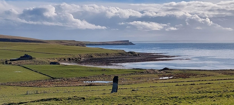
The monument comprises a vertically set standing stone, a mutilated mound and two denuded banks. The standing stone alone was first scheduled in 1953 but an inadequate area was included to protect all of the archaeological remains: the present rescheduling rectifies this.
The standing stone is located on a south-facing gently sloping ground and is oriented NNW-SSE. The stone stands to a height of 2.8m and measures approximately 0.23m thick and 0.9m across. Around the base of the standing stone, cattle trample has exposed a concentration of angular stone but it is uncertain whether these stones relate in any way to the erection of the standing stone. A cairn lies 38m to the W of the standing stone. This comprises a low stony mound standing to approximately 1.3m high above the local ground level and is some 18m in diameter. On its NE arc, the outer edge of the mound is delineated by three upright stones. Early excavation revealed a cist close to the eastern edge of the cairn and a second phase of excavation revealed a stone lined passage leading to a deep stone lined pit close to the centre of the cairn. These excavations recovered burnt and unburnt bone fragments, shell and charcoal from the cairn. A low ill-defined earthen bank approaches the stones from the NNW and terminates at its base. A second low stony bank, measuring approximately 3 m wide, is aligned NW-SE and is separated by approximately 12m from the standing stone at its nearest point. Other low ill-defined mounds exist in the vicinity of the standing stone.
The area to be scheduled is irregular on plan, with a maximum dimension of 80m NE-SW by 55m NW-SE, to include the standing stone, the cairn, the two low banks and an area of ground around these features in which evidence for their construction and use may survive, as marked in red on the accompanying map extract. The post and wire fence that coincides with the NW boundary of the area is excluded from scheduling.
Source: Historic Environment Scotland
The monument is of national importance as a complex of features representing prehistoric ritual activity. The low banks are likely to represent the boundary of the area formerly containing the standing stone and the cairn; this was, until relatively recently, unimproved. There is therefore good potential for the survival of evidence relating to the erection of the stone, to ritual activity around the stone and to the construction and use of the adjacent cairn.
Source: Historic Environment Scotland
Bibliography
RCAHMS records the standing stone as ND48NW 1 and the cairn is recorded as ND48NW 3. The standing stone is listed as No 1835 and the cairn is No 1387 in the Orkney Inventory.
References:
RCAHMS 1946, TWELFTH REPORT WITH AN INVENTORY OF THE ANCIENT MONUMENTS OF ORKNEY AND SHETLAND, 3V, Edinburgh: HMSO.
Source: Historic Environment Scotland
Other nearby scheduled monuments