Approximate Location Map
Large Map »
This site is entirely user-supported. See how you can help.
Latitude: 58.8186 / 58°49'6"N
Longitude: -3.0336 / 3°2'1"W
OS Eastings: 340402
OS Northings: 992805
OS Grid: ND404928
Mapcode National: GBR L5WF.124
Mapcode Global: WH7CW.CLNY
Entry Name: Hoxa Battery and Balfour Battery, coastal battery complexes, Hoxa Head
Scheduled Date: 26 December 1972
Last Amended: 5 March 2015
Source: Historic Environment Scotland
Source ID: SM3268
Schedule Class: Cultural
Category: 20th Century Military and Related: Battery
Location: South Ronaldsay
County: Orkney Islands
Electoral Ward: East Mainland, South Ronaldsay and Burray
Traditional County: Orkney
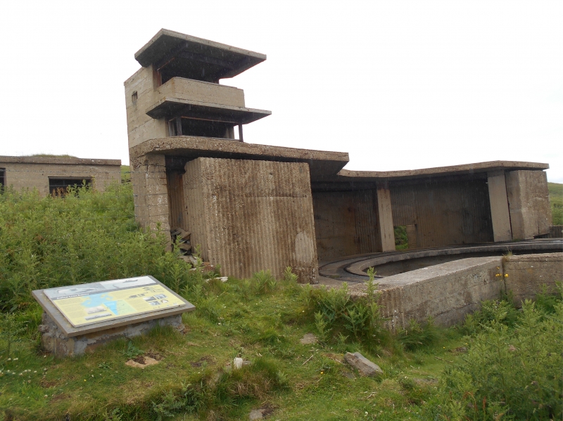
The monument is the remains of a complex of four coastal artillery batteries with associated accommodation camps and ancillary structures. The site was used during both the First and Second World War, with the first battery established in 1915 and the last phase of construction occurring in 1941, although it was abandoned between the wars. It is visible as a series of concrete structures, hut bases and earthworks, extending over a distance of some 700m N-S on the headland of Hoxa Head, South Ronaldsay. It forms part of a network of coastal batteries built to defend the key strategic British naval anchorage of Scapa Flow. This complex of batteries covered the southern route into the Flow in both wars. The site is located between about 5m and 35m above sea level, overlooking the shipping channel through the Sound of Hoxa. The monument was first scheduled in 1972, but the documentation did not meet modern standards: the present amendment rectifies this.
The four main batteries comprise: two First World War 6-inch QF (Quick Firing) gun emplacements; four First World War 4-inch QF gun emplacements; two Second World War 6-inch gun emplacements; and two Second World War Twin 6-pounder emplacements. Other structures supporting the emplacements include three battery observation posts, six magazines, four power houses, four crew shelters, six searchlight emplacements, several general storage and maintenance buildings and the visible remains of at least 32 concrete hut bases and other building remains.
The scheduled area is irregular on plan to include the remains described above and an area around them within which evidence relating to the monument's construction and use is expected to survive, as shown in red on the accompanying map. The scheduling specifically excludes the above-ground elements of the post-and-wire fences around the site, and the above-ground elements of the interpretation panels in place around the batteries, to allow for their maintenance.
Source: Historic Environment Scotland
This monument is of national importance because it has an inherent potential to make a significant addition to our understanding of the past, specifically, the network of defences constructed in the First and Second World War to defend the key strategic harbour of Scapa Flow. This is a well-preserved example of a multi-phase coast battery, showing a wide range of remains of this site type from both World Wars. Its significance is enhanced by the presence of rare features, such as functional fittings and internal decoration, along with the remarkable historic record in the form of stencilling and pencil graffiti within the magazines of the First World War 4-inch battery. The monument offers considerable potential to study the relationship between the various elements of the site, and to enhance our understanding both of the southern Scapa Flow defences and the wider defences in place around Orkney and beyond. These monumental concrete structures are a tangible and powerful reminder of one of the defining events of the 20th century. If this monument was to be lost or damaged, it would significantly affect our ability to understand the nature and scale of the efforts made to defend Britain against enemy naval threats in the First and Second World War and diminish the association between Orcadians today and those who lived and served in Orkney during the war.
Source: Historic Environment Scotland
Bibliography
RCAHMS records the monument as HY20NW 25.
References
Brown I 2002, 20th Century Defences in Britain: an Introductory Guide, Council for British Archaeology, York.
Stell, G 2010, Orkney at War: Defending Scapa Flow - Volume 1: World War 1, The Orcadian, Kirkwall, 64-67.
trove.scot
https://www.trove.scot/place/270386/
https://www.trove.scot/place/9622/
Source: Historic Environment Scotland
Other nearby scheduled monuments